- Water and Wastewater GIS for Municipality of Čoka, Serbia. Mobile Laser Scanning of all water and wastewater utilities in Čoka, Padej, Sanad and Ostojićevo and process collected data. Creation of new geodatabase, populating geodatabase with process data from the field. Implemented newly created geodatabase into water and wastewater informational system of the Municipality of Čoka. Training of employees to use and manipulate geodatabase and gathered data. (2019)
- Water and Wastewater GIS for City of Prokuplje, Serbia. Mobile Laser Scanning of all water and wastewater utilities in Prokuplje and process collected data. Creation of new geodatabase and populating geodatabase with process data from the field. Implemented newly created geodatabase into water and wastewater informational system of the City of Prokuplje. Training of employees to use and manipulate geodatabase and gathered data. (2019)
- Cadastre for small Hydropower plants Serbia. Designing and realization production basic GIS geodata base in ArcGIS environmental with processing collected cartographic and geo referenced data for potential location of small HPP. Producing DTM for Nisava Catchment with data collected by Lidar and photogrammetry equipment integrated with existing geo referenced alphanumerical data. Formed Geo data base are open for further data which will collected by mobile Lidar and photogrammetry measurement promised segment of river valleys of other Catchments in next phase of work (2017-present).
- Production of 3D cadastral topographical maps and orthophoto maps in standard Cad/GIS formats and basic GIS geodata base for Municipality Bor, Serbia. Project area is about 5200 ha. Computer processing collected data by mobile laser scanner installed on car, helicopter and small air plane and data delivered by Republic Geodetic Authority were realised by standard CAD and GIS program package ArcGIS and modules, standard RDBMS program packages. For every realised project were made 3D digital maps in standard CAD and GIS format and generate Basic GIS model which consist processed graphical and alphanumerical data. (2017/2018)
- Detailed Topographic Survey, Control Network, Underground Detection Survey and Property Survey for project in Doha, Qatar. Computer processing collected by mobile laser scanner installed on the car data and data delivered by MMUP and other Utilities companies were realised by GIS program package ArcGIS and modules and standard RDBMS program packages. For every realised projects were made Basic GIS model which consist processed graphical and alphanumerical data. Project area 216 ha. (2017/2018)
- Cadastre of Republic of Serbia mining waste. Designing and realization production GIS geodata base in ArcGIS environmental with processing collected existing cartographic and geo referenced data and field collected by geological and experts. Final product was 3D Mining waste maps with supported basic geo referenced alphanumerical data. Formed Geo data base are open for further data which will produced in next phase of work. (2017/2018)
- Production of 3D cadastral topographical maps in standard Cad/GIS formats and basic GIS geodatabase for Belgrade Urban areas (2010-2017). Computer processing collected data by mobile laser scanner installed on car, helicopter and small air plane and data delivered by Belgrade Urban planning and construction and other Utilities companies, Statistical Authority, Republic Surveying Authority were realised by GIS program package ArcGIS and modules and standard RDBMS program packages. For every realised projects were made 3D digital maps in standard CAD and GIS format and generate Basic GIS model which consist processed graphical and alphanumerical data.
- Location New Belgrade – project area 300 ha
- Location Bezanija – project area 216 ha
- Location Kumodraz – project area 285 ha
- Location Usce – project area 105 ha
- Location Pancevacki rit – Project area 520 ha
- Location Bubanj Potok – Project area 110 ha
- Location Ibarska – Project area 140 ha
- Location Zemun – Project area 58 ha
- Location Obrenovac corridor 1 – Project area 20 km x 0.5 km
- Location Galovica – Project area Corridor 64 km x 0.5 km
- Location Blok 18 – Project Urban area 72 ha
- Detailed Topographic Survey, Control Network, Underground Detection Survey and Property Survey for projects in Doha, Qatar (2012-2015). Computer processing collected data and data delivered by MMUP and other Utilities companies were realised by GIS program package ArcGIS and modules and standard RDBMS program packages. For every realised projects were made Basic GIS model which consist processed graphical and alphanumerical data.
- Topographic survey works for General Engineering Consultancy Services DN071 Al Kheesa and DN073 Zone 30 and 31for Hyder Consulting Doha, Qatar
- Topographic survey works for General Engineering Consultancy Services DN029 South of Legtaifiya for Hyder Consulting Doha, Qatar
- Topographic survey works for General Engineering Consultancy Services North of Mall of Qatar Area and Celebration Road DN110 for Hyder Consulting Doha, Qatar
- Topographic survey works for General Engineering Consultancy Services for local roads and Drainage DN107 Al Froosh & Al Kharaitiyat for Hyder Consulting Doha, Qatar
- Topographic survey works for General Engineering Consultancy Services DN103 Umm Salal Ali for Hyder Consulting Doha, Qatar
- Topographic survey works for General Engineering Consultancy Services Celebration Road DN019 for Hyder Consulting Doha, Qatar
- Topographic survey works for Doha Expressway group 5 – Project 022 and Project 025 for Hyder Consulting Doha, Qatar
- Topographic survey works for Doha Expressway group 5 – Project 026 for Hyder Consulting Doha, Qatar
- Topographic survey works for Pre Contract Professional Design Services for Al Rayyan road and Bustan South Street for KEO Consult. Doha, Qatar
- Production of basic GIS geo database for the project Serbian Real Estate Market Overview (2010-2015) Work as local partner company DANOS – International Property Consultants and Valuers Company – Member of Paribas Real Estate. For this projects of Real Estate Market overview (two times per one year) GeoGIS provide geo database for real estate market analyses. GeoGIS made computer processing collected relevant data and data delivered from official Republic Authority were realised by GIS program package ArcGIS and modules and standard RDBMS program packages. For every realised analysis were made Basic GIS model which consist processed geo referenced graphical and alphanumerical data. Part of one report for 2015 you can find in Annex file.
- Production basic GIS and orthophoto maps for Tamnava River (financing from Swedish EPA and Serbian Directorate – IP 802) as base of project “Development of a first draft Flood Risk Management plan for Tamnava river Basin, Serbia.”
- Production basic GIS (land use, generated 3D model with improved accuracy, hydrology), and orthophoto maps for Vrbas basin (8800 km2), Bosnia and Hercegovina. (2008)
- Production basic GIS (land use, generated 3D model with improved accuracy, hydrology), and orthophoto maps for Timok basin (15.600 km2), Serbia. (2008)
- Production basic GIS (land use, generated 3D model with improved accuracy, hydrology), and orthophoto maps for Lover Drina valley (7.200 km2), Serbia. (2001/2002)
- Agricultural GIS solution and project implementation of farm “Ravnica”, 12000ha Bajmok, Serbia. (1997)
- Agricultural GIS solution and project implementation of farm “Becej”, 18000ha Becej, Serbia. (1997)
- Agricultural GIS solution and project implementation of farm “Delta Agrar”, 34000ha Stara Pazova, Serbia. (2007)
- Information System of Belgrade Sewerage System (2005/2006).
The first phase of the project of providing a mathematical model for the Belgrade Sewerage System includes a sub-phase related to production of an integral digital database about the existing Sewerage System and other ground structures (buildings, roads, green areas) which may influence the System until the year 2020.
- Underground Utilities Information System of the City of Novi Sad (2004/2005).
The basic goal of this project is to establish an information system of underground utilities as a multi user base for maintenance of utility systems and design of their new parts.
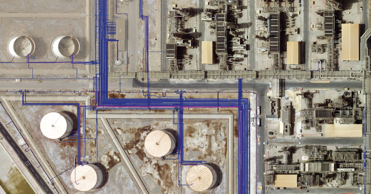
- Detection and generating IS of Refinery Novi Sad, Serbia underground utilities network as GIS applications (2005/2006). GIS solution was prepared to provide records on actual status of underground utilities network of one Refinery Novi Sad part.
- GIS Design and project implementation of Halul refinery underground utilities network, Qatar (2003). GIS solution was prepared to provide records on actual status of underground utilities network of one Rafinery Halul part. For detection underground utilities were used different complementary technology (GPR, magnetic and electromagnetic detectors, sound detectors, ECT).